

Seasons of Remembering
Encountering a village submerged by the damming of the Ljusnan River.

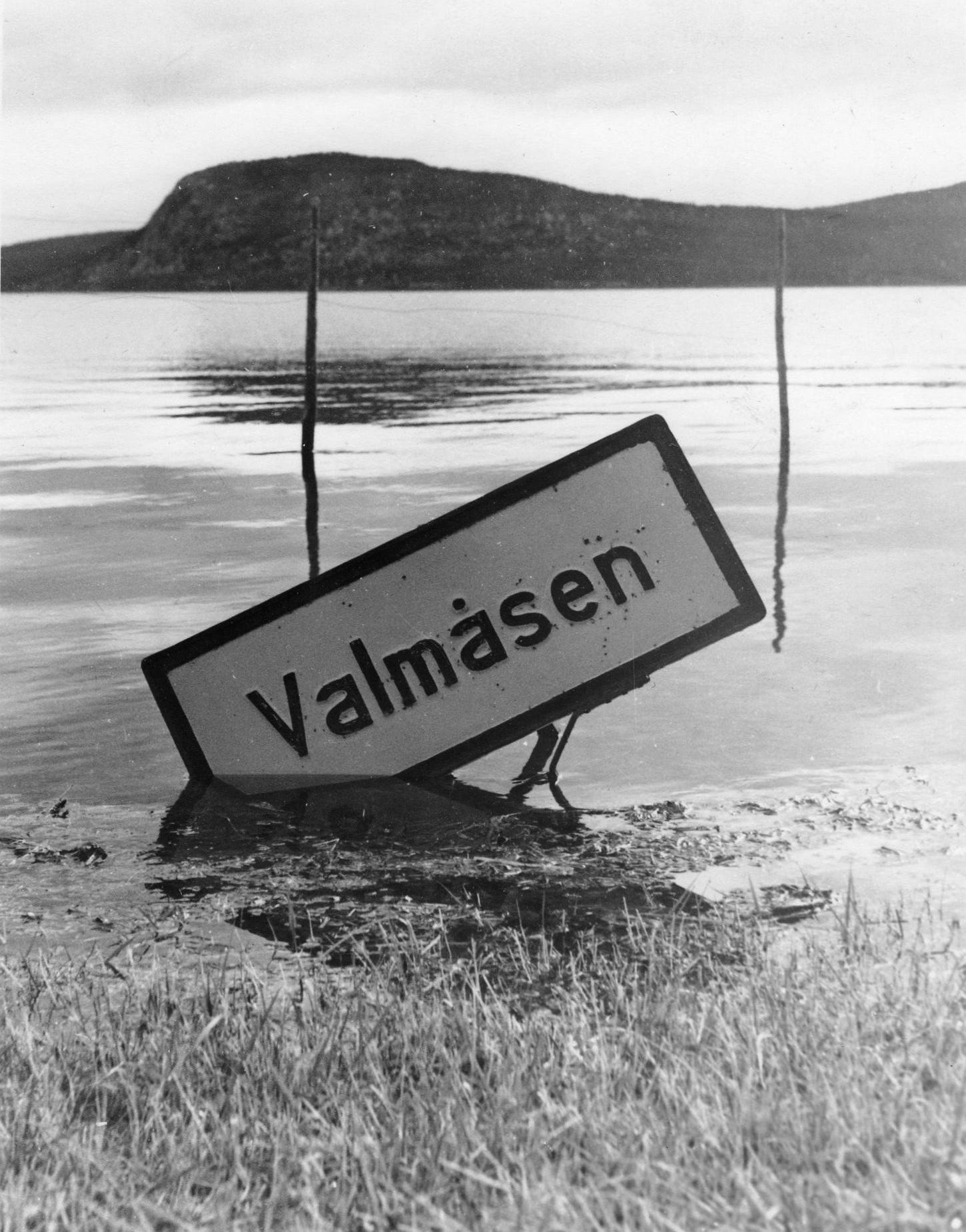
Valmåsen.
Sometimes, a scribble contains the seed of a story.
One such scribble exists in a notebook from the first year of a global pandemic. Whenever my eyes pass it, a blur of birches dressed in yellow leaves appears before the eye of my mind.
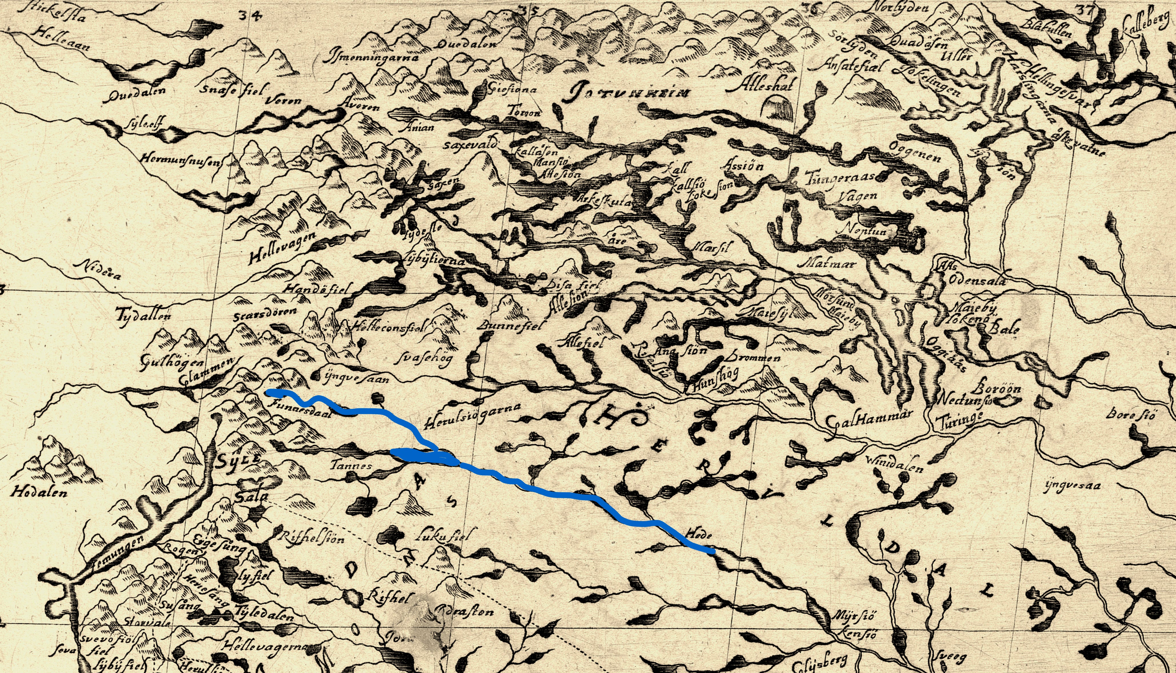
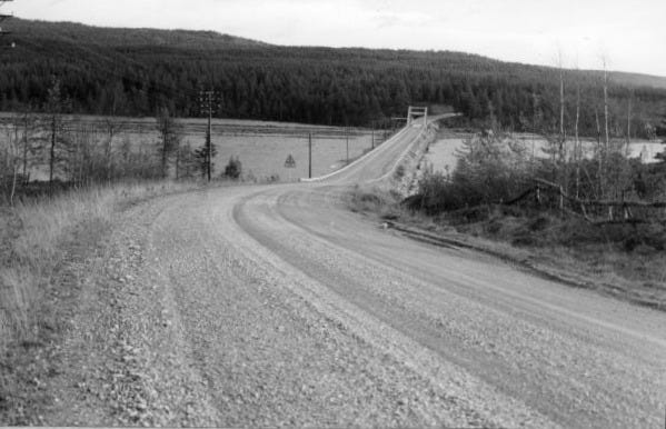
For a few kilometres, our car followed the forested shoreline along a barrier lake. That autumn, I had hitched rides in the deep province of Sweden, following the traces of a historical expedition. A chain of coincidences had washed me up in the village of the Kalendargubbarna and made me friends with Åsa and Olle.

“You know, there’s a village below the lake”, Olle said, lifting his index finger from the steering wheel towards the forest that rolled by.
From the dog barrier behind me, I heard the panting of Semla. During days at their lakeside cottage, the Rottweiler had kept me company. That morning, I had joined Olle and the dog on the way to the vet in Hede. From the small town in Härjedalen, I planned to hitch the next ride north, towards Jämtland.
I turned my head to Olle with what must have looked like a puzzled expression.
“They drowned the village when they built the Lossen dam”.
In short intervals, views opened up through the trees. Down at the lake shore, my eyes traced a drift line, running high above the water level. Parched flotsam, marking how far the snowmelt had risen this year.
Soon, a concrete intake tower rose from the middle of the lake. Further on, the dam wall came into sight.
“There are a few days in spring when you can see the remains,“ Olle added once we had passed the barrier.
“What was the name of the village?” I asked, removing the cap from my pen.
At the River of Light
Two years later, I returned to Lossen.
One of the early friends I had made in Jämtland had lent me his 4x4 to explore the gravel roads along the lake.
Lossen receives the waters of the Ljusnan River, springing some fifty kilometres upstream in the mountains on the Swedish-Norwegian border. This river had been on my map long before I first stood at its banks.
Ljusnan features among the mythical landscapes that Olof Rudbeck projected on his home country. As he unfolded in the Atlantica, Ljusnan was the ‘River of Light’ (from sw. ljus = light), one of the rivers of Norrland along whose course he imagined the promised lands the poet Vergil described as Elysium – the place where the souls of the blessed reside along lush river banks, illuminated by the eternal light of the midsummer sun.

Filling levels at Lossen were still near their lowest when I returned to the lake in May. The month before, the ice had begun melting.
It is during these days in spring that the remains of the drowned village of Valmåsen are visible on its shore – before the snowmelt from the mountains reaches full force, and the waters of the river dammed at Lossen rise again over the ruins of the village that had once been home to many.
i recall the river was an artist
who painted dancing webs on keels
glittering like the trout on our hooks
and who played us songs on April nights
as the floes took leave
a scalpel cuts across our childhood lands
sharp as in Galileo’s lens
dissecting darkness from light
glaring sands drank in the river’s lustre
round the rubble of our houses
stairs leading into void
the stones cast breathless shadows
on banks whose grass once tickled
our feet around the midsummer pole
in stygian waters sometimes a shimmer
the naked piers of bridges
once leading to our home
Underlands
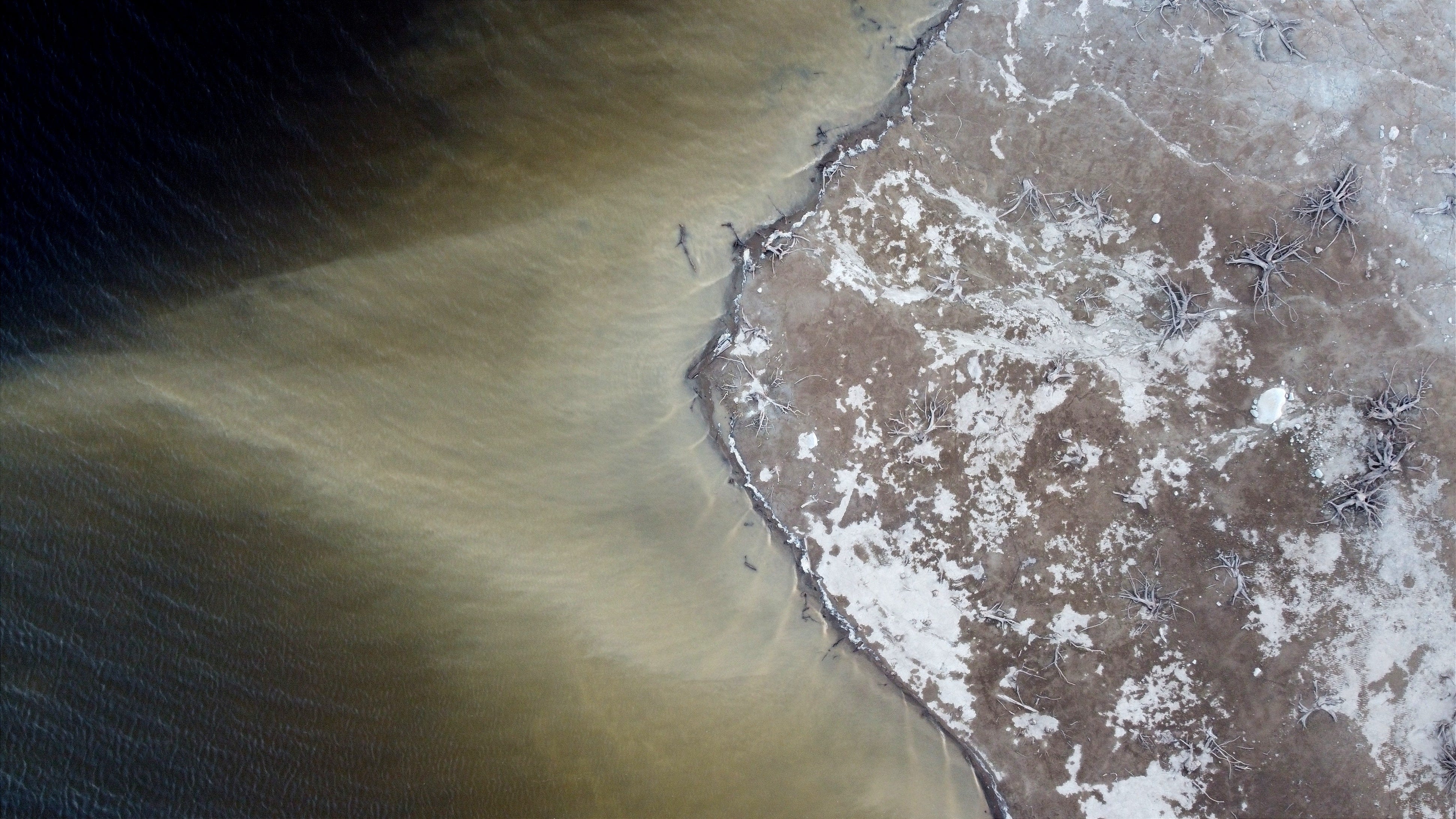
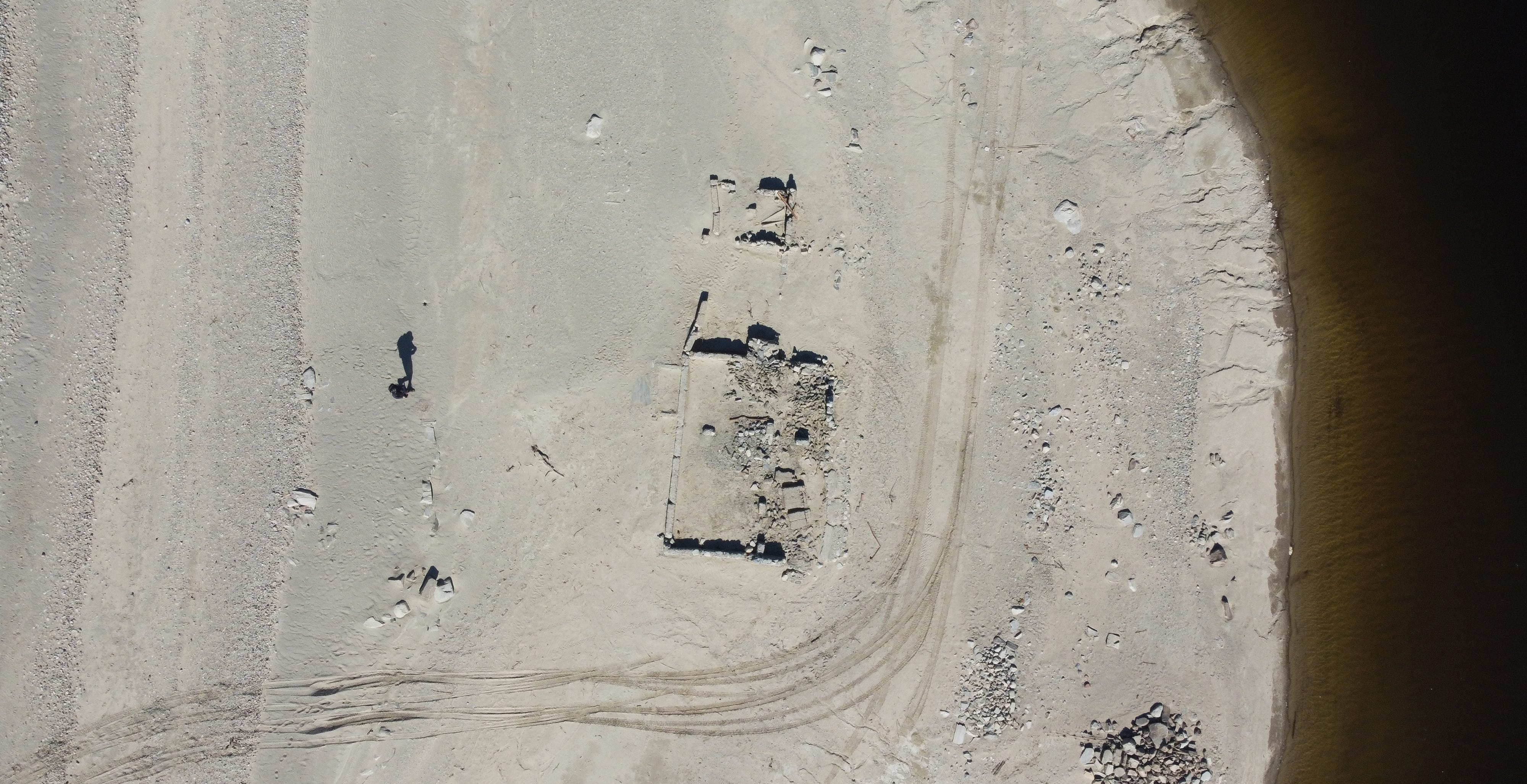
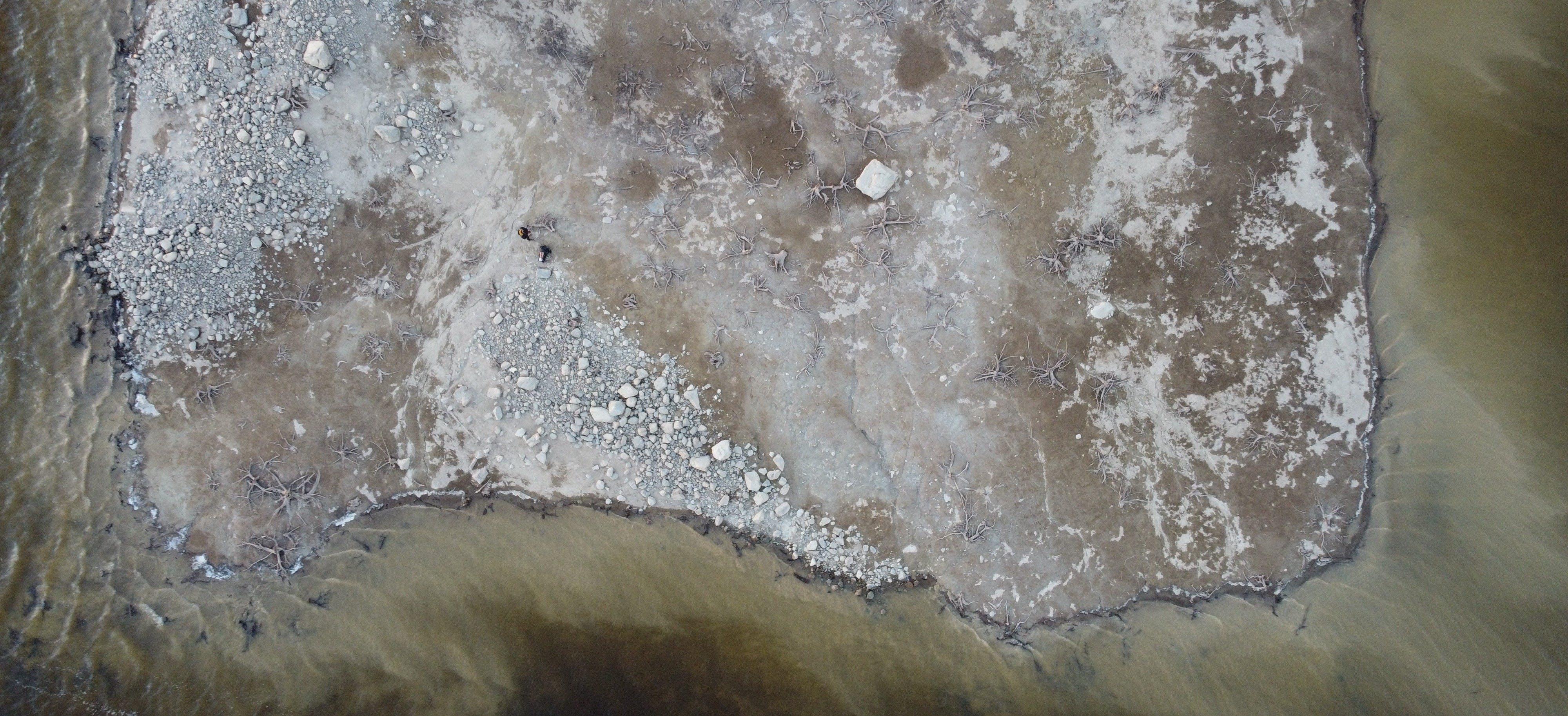
The sun was close to the horizon when I emerged from the forest towards the lake shore. Somewhere across the water, on the opposite bank, lay the ruins of Valmåsen.
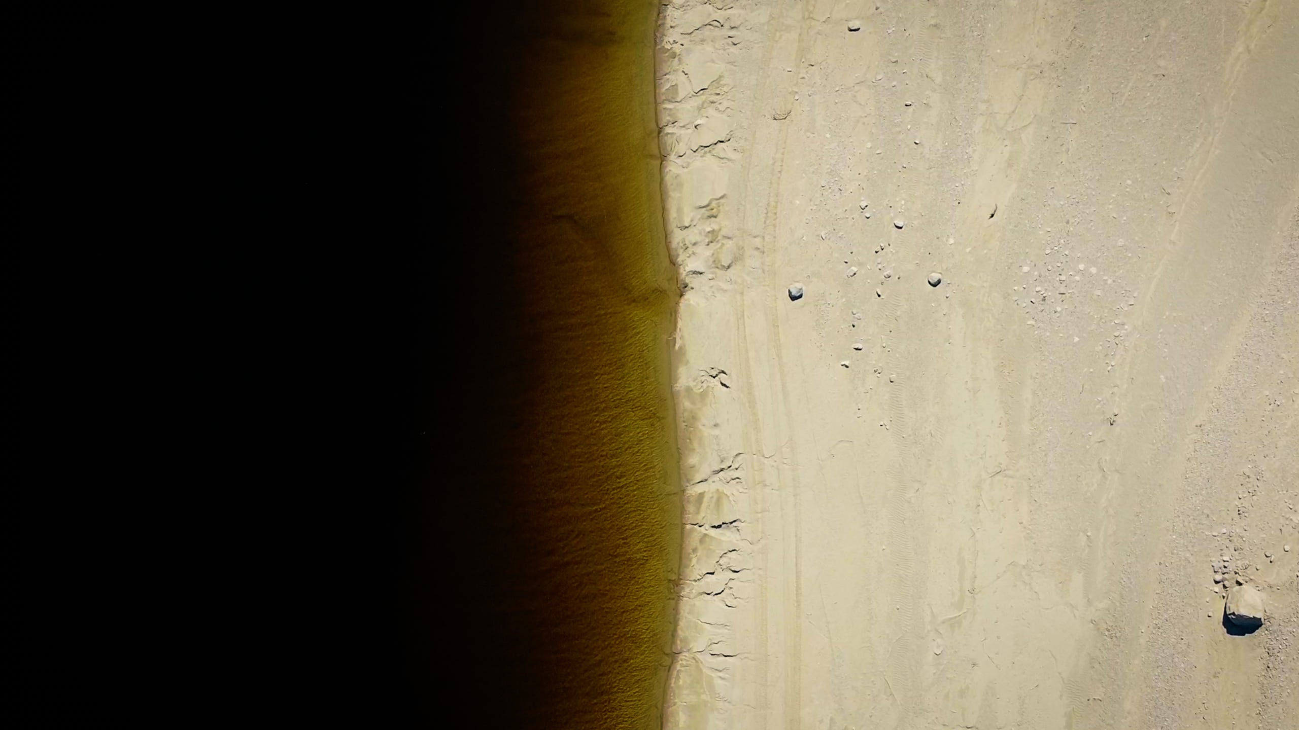
I followed the creeks from the forest down to the lake. The evening breeze drove dust over the rubble on the shore. Half of the year, this was lake floor.
Where its undulating contours cast shadows, snow fields still hugged the ground. Weeks without rain had drawn cracks into the mud where the streams fanned out into the lake.
I knelt down next to one of the stumps sticking out from the arid ground, feeling the water-polished remains of trees stripped bare by sixty floods.
Six decades ago, the ground beneath my knees had been forest.
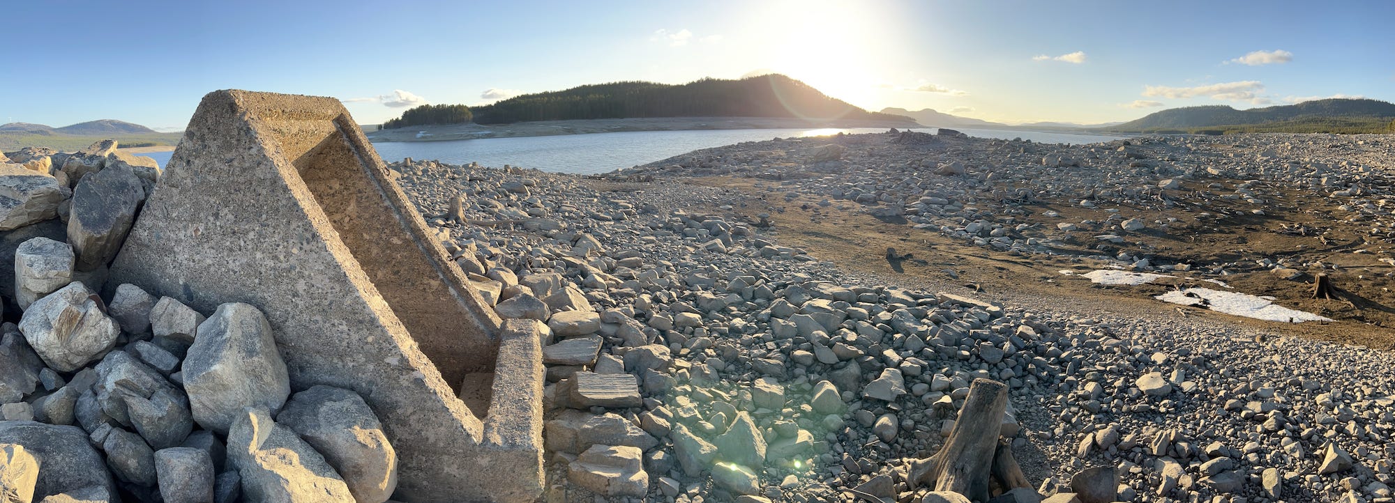
Sand trickled in the cracks between the stones as the evening wind drove the river against the shore. From the field of rubble, concrete shafts stood out like triangular ears, cocked for the silence that shrouded the opposite bank.
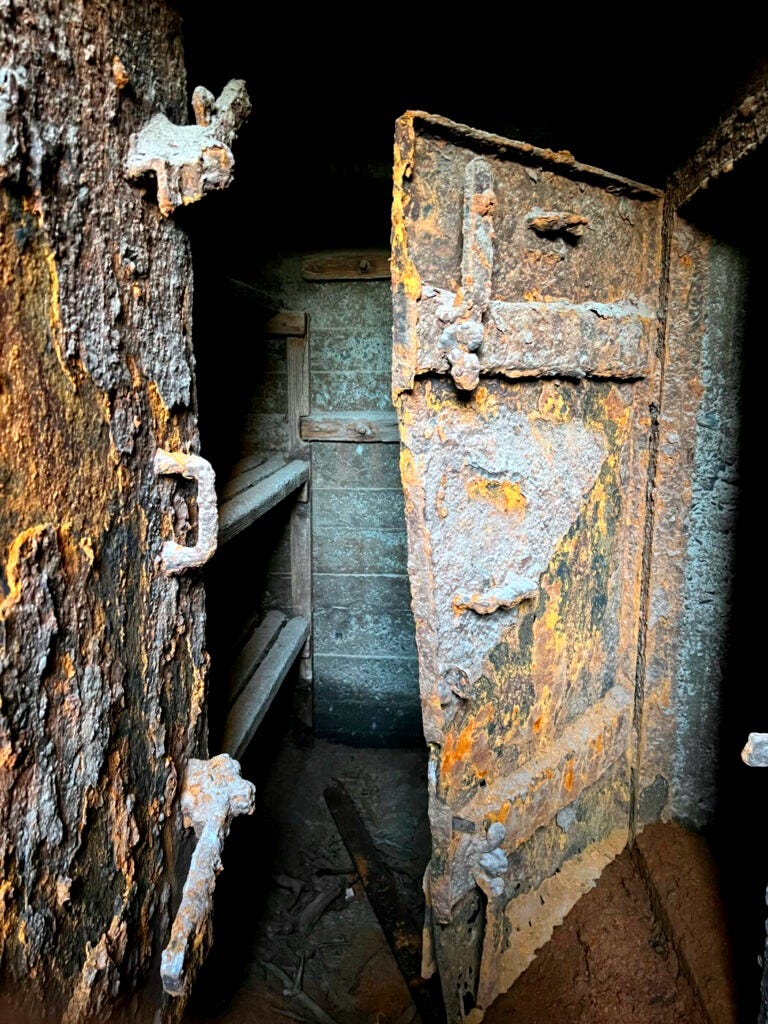
On steps coated in mud, I slid down, slipping on the ice that covered the ground beneath – a few inches of the lake that had flooded the bunker system.
In its mirror shimmered rust and turquoise – the patina of metal doors that sealed the shelter. Here in the ground – submerged for most of the year – soldiers would have held the Ljusnan bridge in case of war.1
Back on the surface, I felt the cloudless sky suck away the warmth from the stones. With shadow fingers they groped for the lake floor.
For a while, my view rested on Ljusnan, its waves smoothing as the widening expanse of the lake received them. Somewhere beneath these waters must lie the piers of the bridge on which travellers once crossed the river towards Valmåsen.
That was until 1962, when the waters began to rise.
the forests fell before the flood
from the trees they built no ark
they moved our homes instead
the kiln of barren banks
has chapped the mud
sand drifting into cracks
stumps hold on to sterile land
stiffened fingers of a severed hand
still clutching at the earth
with each wave passing
the river gnaws away
last crumbs from bony roots
27 Metres
When the snowmelt arrived in 1962, the water level rose by 27 metres. That year, it did not recede.
Four years earlier, the court decision authorised the construction of a dam wall at Lake Lossen. Roads were rerouted to accommodate the future shoreline.
Trees below the projected waterline were marked for cutting. Submerged for most of the year, the rotting forests filled the air with a pungent stench. Dislodged stems posed a threat to boats and to the dam’s infrastructure.
Around Lake Lossen, more than a dozen houses were flagged for removal. At Valmåsen, citizens such as Emil Salomonsson (1902–1983) began to document what they knew would be lost.2
What was about to happen at this village was repeated across the North.
In the 20th century, the Swedish state green-lighted hydropower projects along the rivers of Norrland. A dominant narrative justified such projects by framing sparsely populated regions as acceptable sites of sacrifice, in exchange for benefits to the rest of the country.3
Damages on the margins of the country were politically accepted. They were treated as calculable.
In the 1950s, the National Board of Antiquities (RAA) set up a department (sjöregleringsärenden) to document the cultural losses caused by damming projects. Its work was financed by the very companies carrying them out.4
Soon, researchers were sent to Lossen. Around the lake, they catalogued traces of human presence, from the Stone Age to the present. In their documentation, they passed on the heritage that seemed worth preserving from an ethnographical perspective. It was the largest investigation of its kind ever carried out by RAA.5
Some five years later, the dam wall began operating.
A Heap of Broken Images
I arrived at the other shore the next morning, on the banks I had beheld the night before.
The path from the gravel road led across a scorched expanse, towards foundation walls that rose humbly against the waterline. A glaring sun etched them onto the lifeless ground; sharp shadows that brought to mind lines from a century past:
Son of man, […] you know only
A heap of broken images, where the sun beats,
And the dead tree gives no shelter, the cricket no relief,
And the dry stone no sound of water.T.S. Eliot, The Wasteland (ll. 19–24)

At this time of the year, the lake climbed the shores of Lossen again. Squinting against the sands, I discerned the silhouettes of two children, whipping a fishing rod over the water.
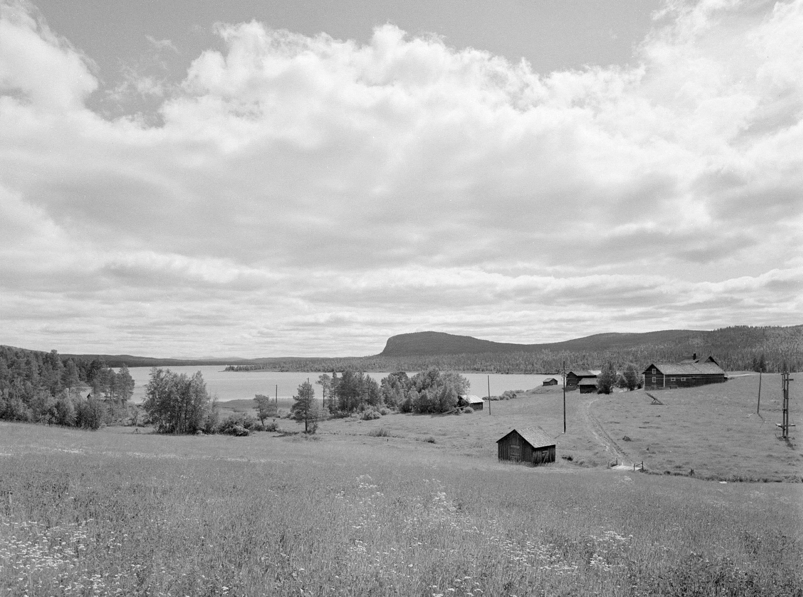
The ruins recall the lives of those who once called Valmåsen home. Black-and-white photographs show faces flayed by the seasons. Loggers left with their axes for nearby forests. Rafters moved downstream, dancing fearlessly over carpets of timber. Families stayed behind, keeping a few cows and living off the land around the village.
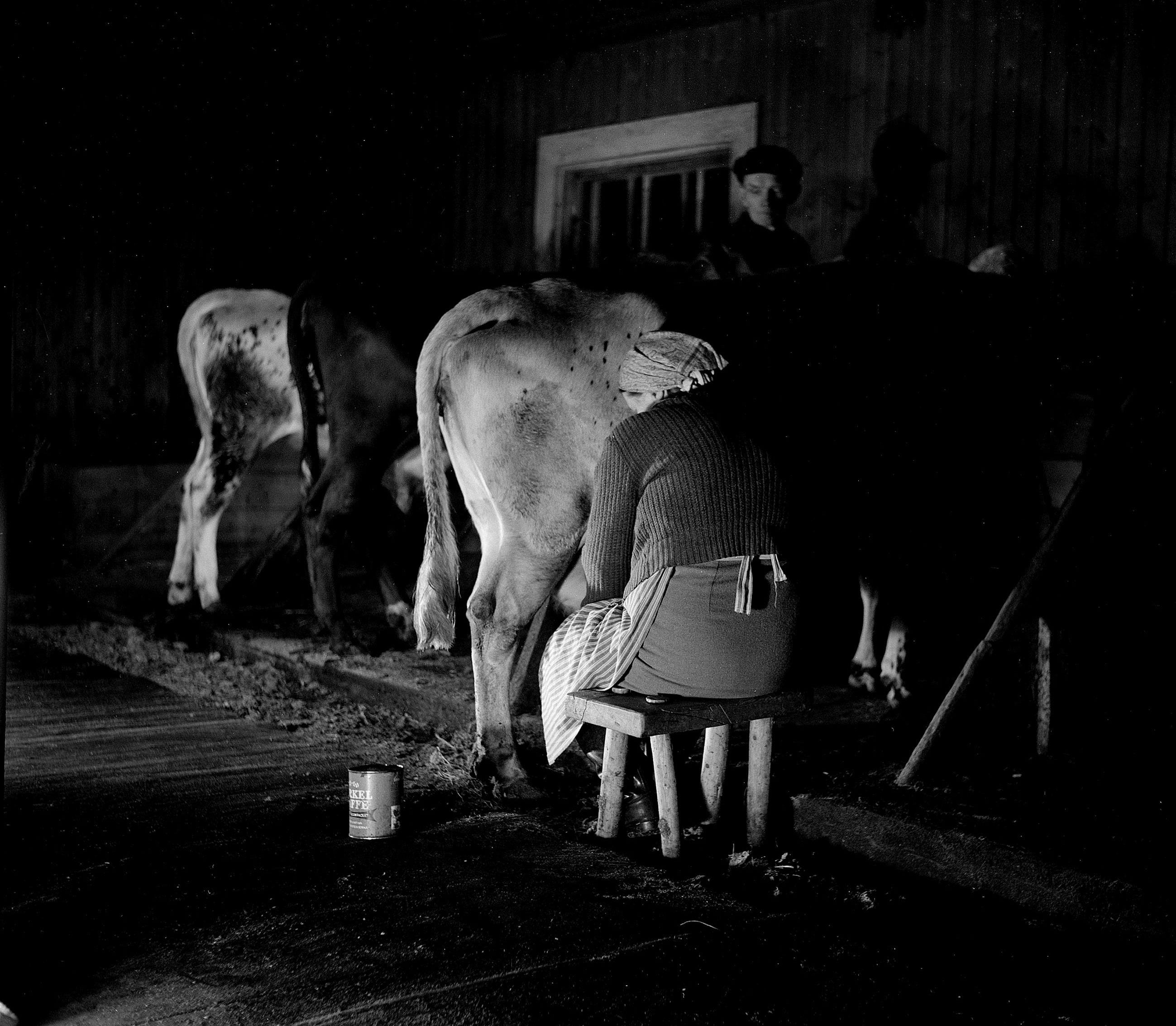
Fishing around Lossen, most agreed, was the best in the region. When the ice melted in spring, fishermen paddled out again with their seines; when the lake froze in late autumn, they bored through the ice with coiled drills.
During the darker seasons, kerosene lamps shimmered in the snow around wooden houses. Behind square window panes, women stitched and men repaired boots. And so the nights passed, until the weeks when the light returned – before the floes started their journey downstream, before the cracking ice woke them from sleep, echoing from the woods.
24,540 Crowns
Lossen was the most upstream in a series of dams which blocked the free flow of the Ljusnan River. Its construction broke a rule valid in Scandinavia since Viking times: that the ways of fish have to be kept open.6
After the damming, fish species that needed to travel upstream to spawn died out in the Ljusnan. With them disappeared the freshwater pearl mussel, whose larvae depend on salmonids.
The islossning – the awe-inspiring spring break-up when ice would travel downstream in floes – became a phenomenon of the past.
In the first summers after the damming, the water rose on overgrown shores, washing excessive nutrients into the lake. After a first and unsustainable spike, the fish population in Lossen plummeted. Shores that alternated between snow, ice, water, and sun turned barren. Perch and pike that spawn in ground cover at certain depths disappeared.
The damage to the ecosystem was reduced to a number. Swedish law required compensation for those affected by changes in fish population. 24,540 crowns was calculated as the amount of damages – corresponding to the estimated market value of the fish meat in the lake.
To those deemed eligible, their share arrived as a cheque.7
One Grievous Night
I stopped a little farther down the lakeshore, where my steps sent blinding sands skidding into the lake. The black water gnawed into the shore, and I kept a few steps above its line that neared the ruins.
Next to foundation walls rose a flight of stairs, like a concrete victory podium split in half, leading nowhere. From their top, I saw the children playing with a rubber boot the lake floor had released.
On the ground next to the stairs, rusty lines trickled towards the waterline. The rivulets traced further up the shore, to the remains of a bicycle pressed into the sand, its spoke rings curling inward like an ammonite.
The shore lay speckled with fossils from a fading past, a sterile expanse evoking that passage in which Plato described the fate of Atlantis:
In one grievous day and night the island was swallowed up by the sea and vanished, wherefore also the ocean at that spot has now become impassable and unsearchable, being blocked up by the shoal of mud which the island created as it settled down.
After Plato, Timaeus8
The Last Link
At the end of the barrier lake, I scanned the horizon, searching for signs of the dam wall. Even from the top of the stairs, the curvature of the earth hid its crown.
In the sky above, clouds moved in from the north-east. Some hundred kilometres in this direction lies Frösön Airbase near Östersund.
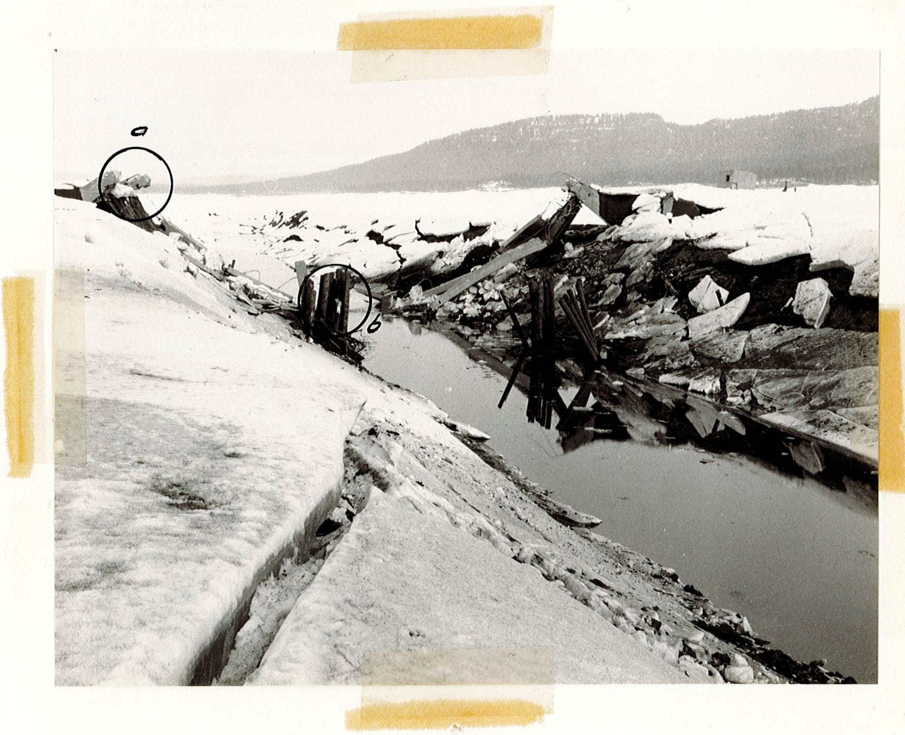
On 25 April 1963, a squadron of J29F fighter planes took off from their runway on Lake Storsjön. After about a quarter of an hour, they turned left, following the course the Ljusnan traced across the snowy ground.
Where the river widened into Lake Lossen, a concrete bridge spanned over Ljusnan, its arches still encrusted with ice after a first season underwater.
Three kilometres south of it, a radio bus had been stationed that morning. Through binoculars, air force officers watched as the planes descended in pairs.
When the flooding of Lossen was carried out in 1962, the military had requested permission to practise target shooting on the Ljusnan bridge. With the old road on the northern shore and the village of Valmåsen abandoned, the structure had lost its purpose. For the military, it offered an opportunity to study the effects of 14.5cm armour piercing rockets on a concrete structure.
At 10:30 on 25 April, the first wave of planes came in. In total, eighty rockets were fired. From the radio bus, officers recorded the angle and effect of each shot.
After the roar of the planes faded in the early afternoon, the officers went out onto the ice to assess the damage. Others headed into the forests to examine whether any reindeer had been hit by shrapnel.
The bridge still arched over the riverbed when the last jets thundered back to Frösön Airbase. The following day, they returned.
The first rocket – no. 29 in the protocol – struck its bow. Three seconds later, half the roadway collapsed into the riverbed. Through the rest of the morning, and again after the lunch break, successive waves fired into the debris.
“The salvos lay well yet didn’t pulverise the remains“, the officers concluded in their report.9
Remembrances
It was after my return to Östersund that I read up on the bombardment in a local newspaper archive.
One article reported that a crowd of several hundred people had gathered on the shore of Lake Lossen to watch the spectacle.10 When the last explosion rang out, the squadron leaders flew an extra round over the masses, the roar of their planes mixing with the cheers of the crowd.
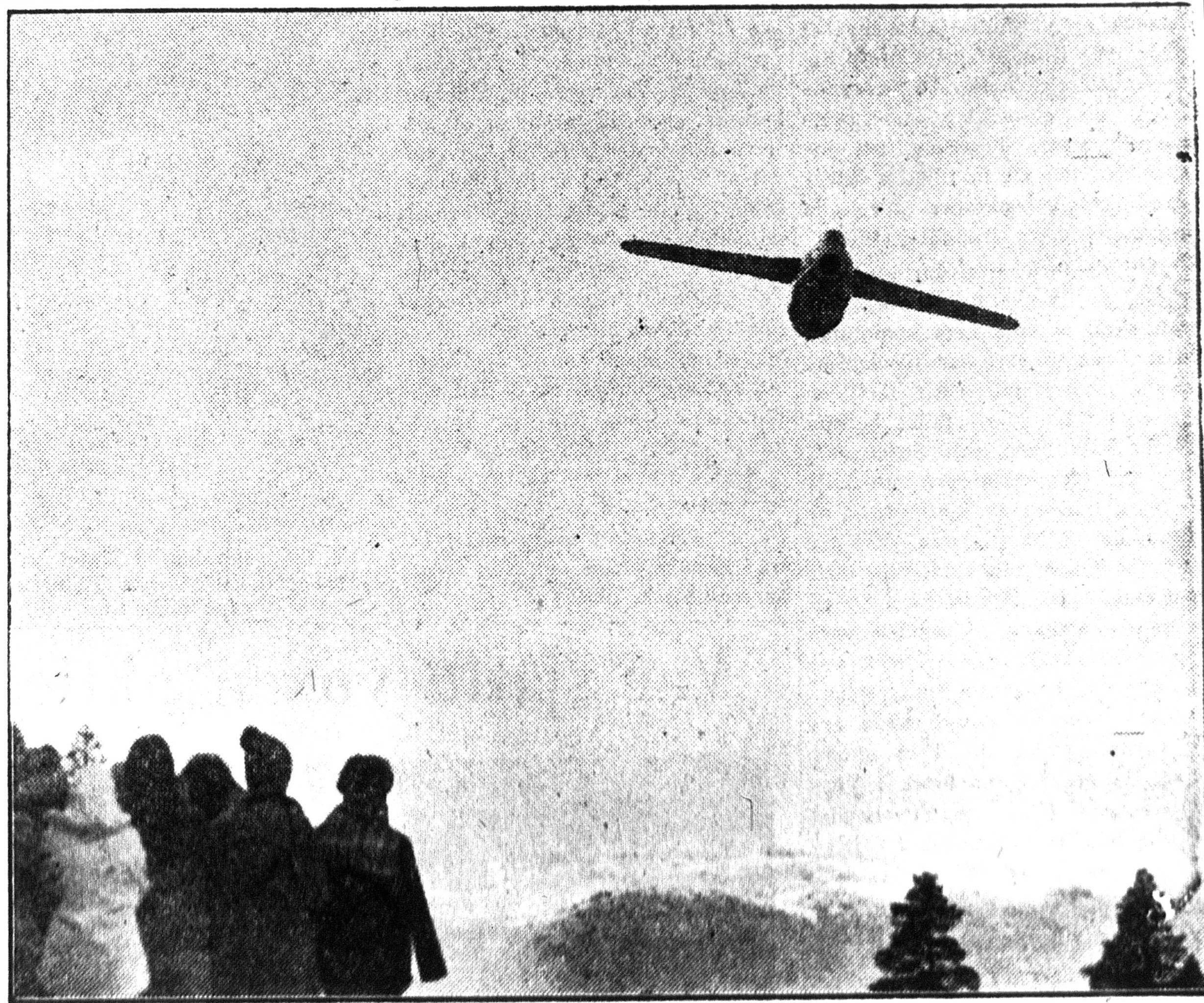
The newspaper printed a photograph from that moment. Among the heads of spectators were silhouettes of children’s beanies. The school in the nearby town of Tännäs had given the students the day off for the impending spectacle, the article noted.
“I think Olle was one of them,” Åsa said when I called her from outside the archive – “I’ll ask”.
“Yes, he was there”, she confirmed later that afternoon.
“He was too little to remember.”
Further reading and references
All photographs, poetry, and translations are my own unless stated otherwise.
Acknowledgments
For conversations, material, and support I thank Åsa Evertsdotter, Felix Dobslaw, Olle Larsson, Kerstin Myrtennäs, Jan Salomonsson, and the staff of RAA.
My account of the history of Lake Lossen and the effects of the damming relies on Emil Salomonsson, Valmåsen. Lossens reglering och överdämningen av Valmåsen, redigerad och uppdaterad av barnbarnen Jan Salomonsson, Anders Svensson och Kerstin Myrtennäs, Hållnäs 2014.
Parts of the destroyed Lossen Bridge have been turned into a veterans’ monument at Sveg, Härjedalen. It was inaugurated 29 May 2022.
Appendix: The Fish Reset in the Lossen System
Around Lossen, the local fish populations were affected beyond the actual damming.
The electricity from the waters dammed at Lake Lossen was produced several kilometres further downstream. Through a tunnel, the lake-turned-reservoir fed into an underground power station at Långå. Two other lakes, Övre Särvsjön and Grundsjön, fed into the same turbine.
After the demise of the original fish population in Lossen as a consequence of the damming, authorities decided to make this lake home to a population of charr (röding), a species appreciated by sports fishers. In Övre Särvsjön, whitefish (sik) was endemic.
Once the tunnel system was finished, Swedish authorities anticipated that whitefish would eventually wander into the other lakes. With whitefish being a more effective plankton absorber, this would have meant the end of the charr population in connected waters.
In consequence, they decided to ‘reset’ these lakes containing undesired species of so-called skräpfisk (‘trash fish’) and to make them home to game fish.
Between 26 and 28 August 1974, 25,000 litres of Rotenone solution were released into Övre Särvsjön. This nerve poison paralyses the breathing of fish.
A silver belt of dead fish, hundreds of metres broad, soon floated against the dam walls. Leaking out, the toxin later wreaked havoc on other lakes and in contributories to Ljusnan.11
It was the largest application of the toxin ever seen in Europe.
Please note the general bibliography available here.
On the abandoned bunkers see the account by Steven Hellan on his blog “Militärhistoria Z”.
The documentation was published in 2014 as cited above.
See Sverker Sörlin, Framtidslandet, augmented edition, Luleå 2023.
See Margareta Biörnstad, Kulturminnesvård och vattenkraft 1942–1980, Stockholm 2006, p. 106.
See Biörnstad, Kulturminnesvård, p. 215. See also Harald Hvarfner, “Riksantikvarieämbetets undersökningar 1957 i samband med vattenkraftutbyggnader”, Fornvännen 53 (1958), 77–80 (online at diva-portal.org).
The commissioned documentation resulted in the book Lossen. Liv och arbete vid en Härjedalssjö, ed. by Harald Hvarfner et al., Lund 1961.
The original investigations are kept among the SR-rapporter at Stockholm, RAA.
See Salomonsson, Valmåsen, p. 110.
See Salomonsson, Valmåsen, pp. 113f.
After Plato, Timaeos, 25c–d (English translation online at Perseus Digital Library).
My description and the photographs draw on the official report “Rapport från skjutning av gamla landsvägsbron vid Valmåsen 25-26/4 1963” (Stockholm, Krigsarkivet, Jämtlands flygflottilj, Stabsavdelningen, hemliga arkivet, F1:10), and the newspaper report mentioned in the note below.
See the article “FN: F4-tunnorna anföll bron”, Östersunds-Posten, 26 April 1963, pp. 1 and 4.
See e.g. Hans-Olof Jonsson, “Katastrof för alla som lever på fisket”, Aftonbladet, 15.11.1974.
For the wider context see Karl-Jakob Gustafson, Nils-Arvid Nilsson, Erik Olofsson, Övre Särvsjön. Konsekvenser av rotenonbehandling av en stor norrländsk sjö, Drottningholm 1981, and Göran Tobiasson, Användning av rotenon i Sverige, Drottningholm 1979.