

Second Exposure
Encountering Sarek, guided by its records over time.

In the memory of Tyrone Martinsson.
Glimpses of Time
My first pick from the table was a pack wrapped in artist paper.
In the basement of Uppsala University Library, the curators had prepared notebooks and maps for me, survey records and photographs – material from three decades that a Swedish mineralogist spent in the most inaccessible region of his country.
The package weighed heavy in my hands, marked with a note in pencil on the paper.
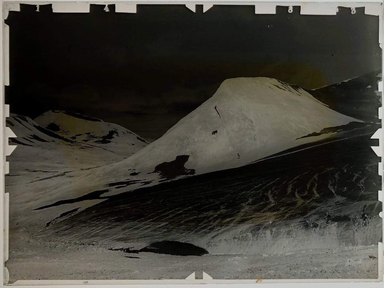
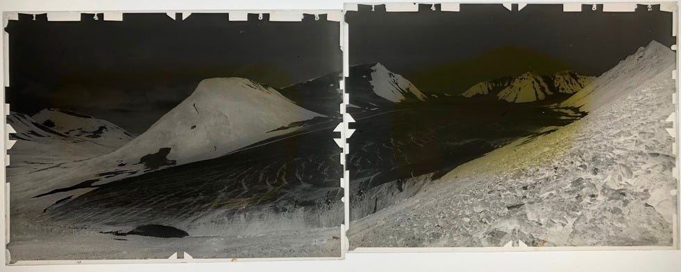
Mikka Glaciär, Sarek (1907).
From its inside I unwrapped three glass negatives.
Some 110 years ago, reindeer carried the fragile load packed in light-tight boxes, bobbing in wooden crates on the animals’ backs next to tripods, tent sheets, surveying instruments, and supplies calculated to last for weeks.
Between my fingertips, I felt the rough edges of the 18x24cm plate.
In August 1907, a man removed it from the protective envelope, fixating it with metal clamps in the housing of a wooden camera. Stabilising the tripod on rocky ground, he centred its angle on a mountain across a glacier valley.
Eyes locked on the pointers of his pocket watch, he removed the lid.
For an exact amount of seconds, the light of Arctic summer fell through the lens. At the back of the camera, its rays reacted with the chemicals thinly spread across the plate.
More than a century later, the mountain’s white silhouette appeared again on my light table, flickering like a ghost as the lamp fizzed alive.
The anvil-shape of Jållok, and beneath, the tongue of Mikka Glacier oozing into the valley, its edges furrowed like the cut of a salmon.
Vantage Points
The path I had followed to the map room at Uppsala had started in a book.
At the Royal Library in Stockholm, I had prepared my map for a solo crossing of Sweden’s most alpine region. During this time, I had come across Frusna ögonblick (‘Moments Frozen in Time’).
In the artfully illustrated book, Tyrone Martinson and Per Holmlund presented the history of photography above the Arctic Circle.1 One of the chapters covered Axel Hamberg, a founding father of modern glaciology – and the man who had made Sarek visible in photography.2
What struck me just as much as the histories the book related was its artistic dimension. Not only had its authors sifted through archives of photographs, or even of early coastal drawings. They had made an effort to identify the spots from where they were taken, many decades and even centuries before – and photographed them anew.
In its visual language, the book intuitively unfolded the chronological dimension of landscapes and the speed of change in Nordic environments.
To both authors I wrote after reading Frusna ögonblick. Both of them replied.
Some weeks before I set out for Sarek I met with Per at Stockholm University. Sarek is the home to 100 glaciers. In 1895, Hamberg first set out to study them. Over decades working as glaciologist, Per has revisited many of them and deepened our understanding – of Mikka Glacier in particular.
Its ice, he explained, is currently retreating by roughly twenty metres each year. A stub near the accumulation zone has remained comparatively stable. Yet all across the glacier, signs of rapid ageing are evident.
Elsewhere in Sarek – and across Sweden – these changes are even more dramatic.3
“Do you think people would miss the glaciers?,” I asked.
“The truth is that most of them are simply out of sight,” Per replied after a moment.
“It’s simply too far away for people to realise what is happening up there."
The Glacial Dimension of Time
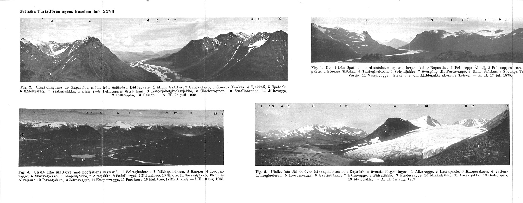
With his photographs, Axel Hamberg deepened our vision of the North by more than a century.
For decades, he returned to Sarek with a team of researchers and Sámi assistants. Applying photogrammetry – a technique Hamberg had honed on earlier expeditions to Svalbard – he created maps from photographs of the glaciers and valleys.
In the previous century, when the theory of the Ice Age first emerged, scientists had begun to read the landscapes of the north as the work of ice. Glaciers were seen as last remains of a massive ice sheet that once had covered the north, and along whose receding edge life had spread.
Hamberg combined meteorological measurements with surveys of glaciers to gain insight into their “metabolism”. Across the region and even on top of 2000m peaks, his team constructed five observation huts.4 Shielded by layers of cotton pressed between sheet metal, a coming generation of professors began their careers. As Arctic hermits, they plotted weather curves as the rest of Europe sank into war.
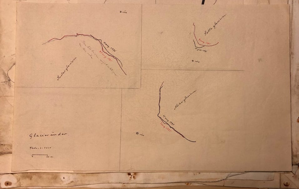
With contraptions made from bamboo, the researchers walked out on glaciers to measure the snow accumulation. With rows of painted stones on the ice, they assessed the speed of the ice.5
The sketches resulting from their observations show the rims of glacier tongues as they changed across the year. What the eye alone can’t hold they made visible – the glacial dimension of time.
Finding Allies
The second author who replied that summer I met already on the way towards Sarek.
I met Tyrone Martinsson in a harbourside café, after a conference in Gothenburg. The conversation rambled around the North – his expeditions to Svalbard, climbing on the Lofoten, his work on Andrée’s ill-fated balloon expedition to the North Pole.
Also, we touched on working beyond the established landscape of academia. One thing Tyrone always stressed was the importance of finding your allies, regardless of disciplines – in the present as well as in the past.
For long, our talk revolved around the 19th-century polymath Alexander von Humboldt – about the diagrams in his Kosmos and his way of bringing together science and the humanities.
Much of this I found again in articles Tyrone sent me after our talk. In one of them, he formulates the challenge against which art and the humanities will have to measure themselves in the twenty-first century:
Climate change is a challenge that requires the mindset of Humboldt in seeing that everything is connected and it needs a visual language to tell stories of the impact and solutions of those challenges, as well as to provide a tool for a narrative of a world worth saving.6
Reading Ice
My first encounter with the glaciers of Sarek was aural, not visual.
In the light of my headlamp, I had pitched camp near the mountain pass in Lulijvágge, some 1400m high. The next morning, I woke up to cracking sounds.
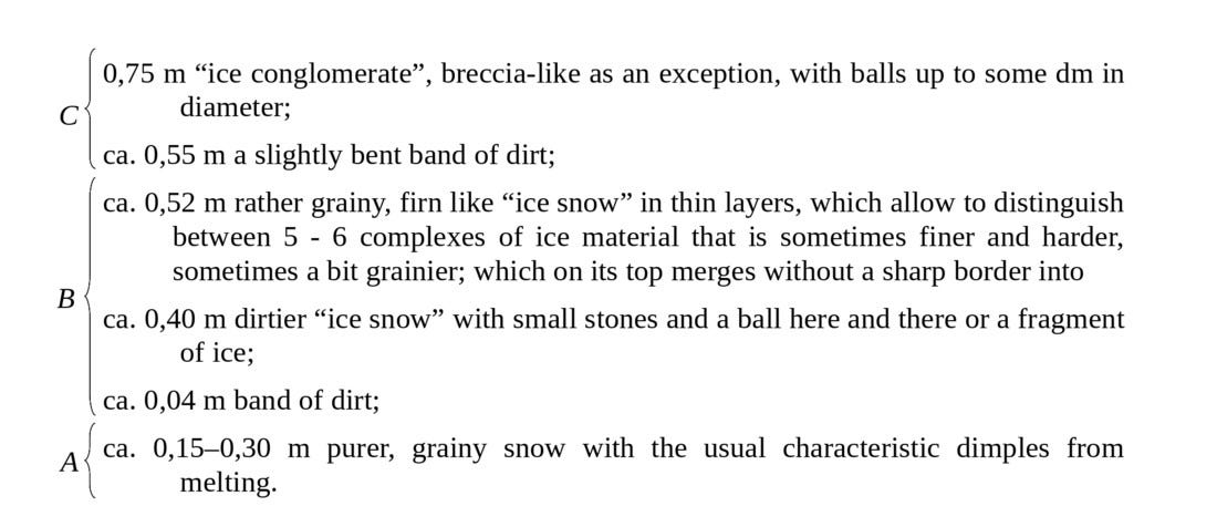
On the ridge along the pass, sunlight had begun to touch the ice nestling in a mountain shoulder. Approaching the glacier, I saw the layers etched against the cliff.
Their sight elicited a diagram from a glaciological volume I had studied in the Uppsala library, the bands of ice laid bare like dissected tissue.
The thought brought to mind The Anatomy Lesson of Dr. Nicolaes Tulp.
In Rembrandt’s painting, a body is laid out on an anatomy table, the muscles and sinews of a forearm dissected. Scientists surround the body, yet their gaze moves away from it, in favour of an opened anatomical atlas.
In this, as W.G. Sebald wrote in The Rings of Saturn, “the appalling physical facts are reduced to a diagram, a schematic plan of the human being”.7
There are sides to glaciers which reach us beyond their schematic reduction. Stories travel with them, a living archive written by the ashes of forest fires and eruptions that eclipsed the skies, by remains of plants and animals and the pollen of each new spring. The fallout from nuclear bombs and reactor catastrophes moves with the ice, too.
Indigenous peoples who live in the vicinity of glaciers intuitively resorted to biological metaphors as they realised their dynamics – that glaciers shrink and grow; that they react to their environment.8
Early glaciologists resorted to similar ways of describing glaciers. Like the nail or claw of a body, Hamberg wrote after one of his early journeys into Sarek, their ice moves and grows. Near their brim, they give birth – they “calve”.
Under the right conditions, a colleague argued, even new ones can be born from snow patches on mountain shoulders that turn to glacier ‘embryos’.9
Contour Lines
I had woken to the sound of ice that morning on the mountain pass.
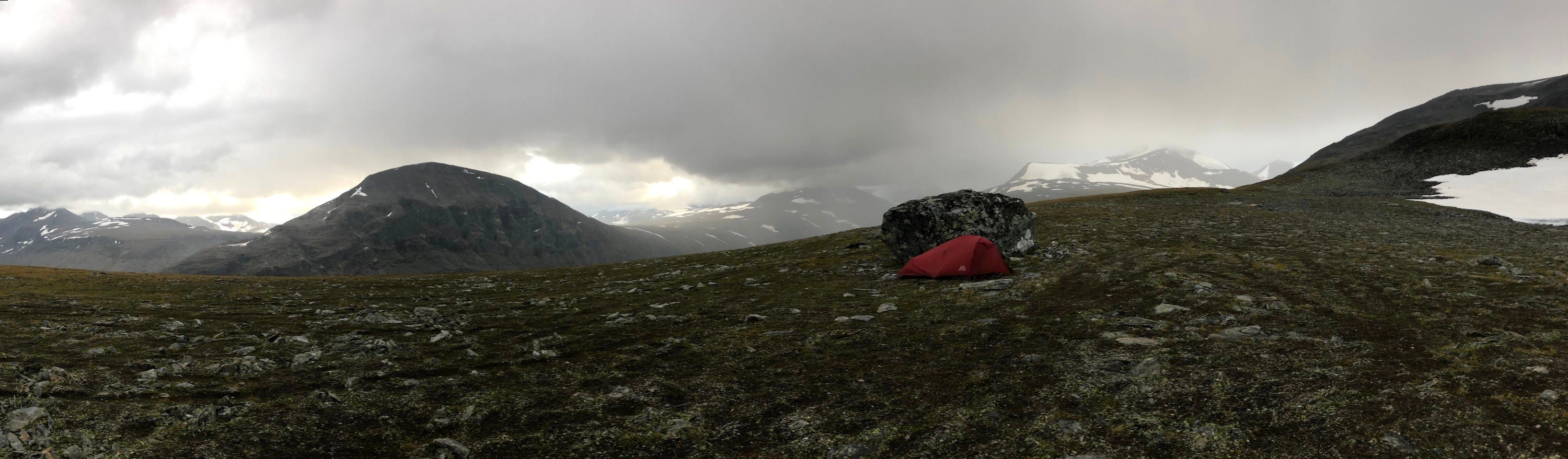
At the end of the day, my view wandered back where I had spent the night, from the high plateau of Dielma where I pitched tent for the next.
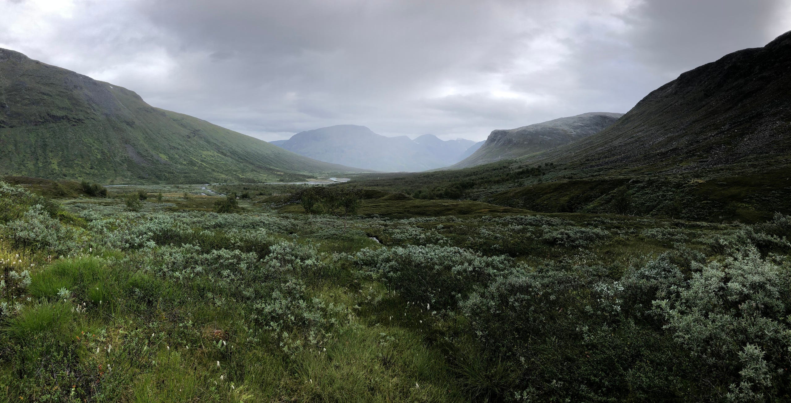
Clouds began to veil the Lulijvágge from where I had made my way down; had seen the first green return after two days of wandering fields of rocks.
Through a mottled forest of birches I had descended into the Sarvesvágge. On my retina, the palette of colours enlivening the ‘valley of the reindeer bulls’ was still fresh. Tufts of cotton grass that swayed over starburst mounds of green. Sage-coloured willows, their soothing hues broken by the lime of Angelica archangelica and its lurid pompom balls.10
Through their undergrowth I had waded towards the Sarvesjåhkå I had to cross. On my skin I still felt the cold touch as willow leaves brushed off droplets from the last rain; recalled their cling lifting again as I emerged from the shadow line that the peak of Noajjde drew across the valley.
On the other side of the zipper I had placed my boots that night, their leather still soaked from the milky waters of Sarvesjåhkå.
They wouldn’t dry again this journey.
On the canvas I heard the rain come in. As night fell, I drifted back into Sarvesvágge, and from there into a week of wandering through Sarek; days unfolding into glacial rivers pressing against my thighs, the sound of cracking ice, carpets of green, and the shifting light above.
When I close my eyes, I can still return.
Many who visited the farther valleys of Sarek left with a sense of embeddedness. One whose lines I had followed years before I set out is Dag Hammarskjöld.
In his posthumous journal Vägmärken (“Waymarks”), the Secretary General of the UN traced glimpses from experiences where windows opened into the connected nature of things.11 Many of these experiences trace back to Sarek.
One of his four tours Hammarskjöld described in an illustrated article, published in the journal of the Swedish Tourist Association. It led him through the Sarvesvágge, in the shadow of Noajdde.

What registered strongest with him on this crossing of Sarek was the light: its inexhaustible changes, the colours it played on the glaciers and in their vaults, into which he and his companions entered along streams that shaped the caverns, their flow nourished by crystal water that dripped from the green-blue ice above, gathering into the foaming rivers that are the milky veins of Sarek.12
The photographs by Axel Hamberg open a window of a different kind. His black-and-white glass plates convey a sense of vastness that embraces visitors to Sarek. Human presence – if visible at all – is dwarfed by the landscape in his photographs.
One of them depicts the mountain of Noajdde, seen from the northern bank in the valley. Sámi porters lead reindeer through the glacier-nourished waters of Sarvesjåhkå as the north face of the peak rears before them, like a wave of rock on the verge of breaking.
In 1922, Hamberg would reuse panoramic views his negatives created of Sarek to illustrate a guide for the Swedish Tourism Association.13 Before he set out on his first journey and long before the hikers followed, Sámi herders have driven reindeer through its valleys.
Before Sarek first appeared on early maps, they gave names to the rivers and to the mountains of the region, and with them inscribed layers of meaning in the land.
Noajdde designates the ritual specialist in Lule Sámi language.
One of them lived in this area, an elder Sámi I met at the southernmost of Hamberg’s huts had told me, the last in the region. For his sessions, this noajdde retreated deep into the valleys Sarek – into the silence of the Sarvesvágge, at the foot of the mountain named after his profession.
Rain played on the canvas throughout the night. By morning, the clouds over the valleys around Dielma began to scatter.
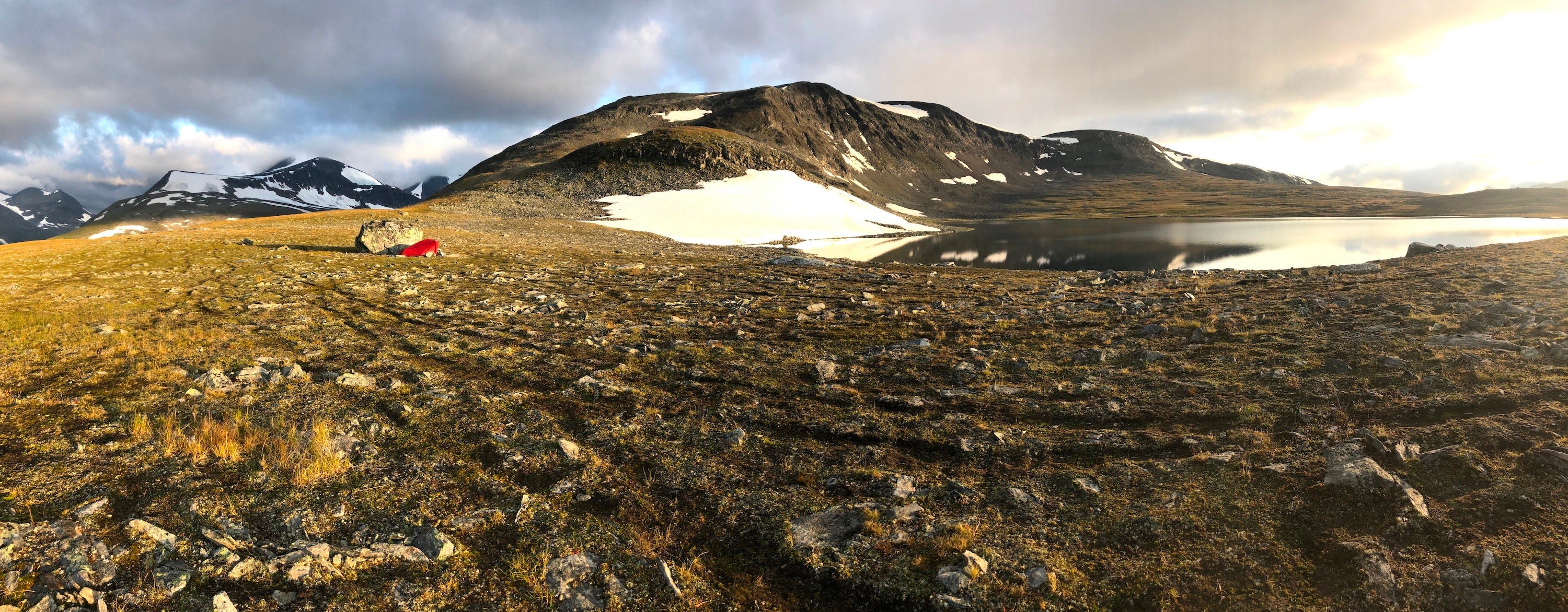
Squeezing into a pair of frozen boots, I slipped the cold gas cartridge in my down jacket. A rim of old ice still lined the southern shore of Lake Dielma. On its tongue I kneeled out to fetch water.
On the opposite shore, I saw the sun rise over Sarek’s main ridge, pouring first light over the last remains of snowfields that hugged the slopes around me. A few weeks from now, the new snow would come in.
The rays warmed my face as I gazed to where my journey was headed – Sarektjåhkkå, beneath whose peak the valley of Mikka Glacier ebbed out.
As I turned my back towards the sun, I saw a figure on the ground, delicate as a work by Giacometti.
The early rays stretched my silhouette across the plateau, across creases that the low light had begun to fill with shadow. In undulating course, their furrows followed the terrain, as if retracing the contour lines on which the reindeer had, by intuition, wandered.
For a moment, it seemed as if the ground revealed traces running through it – ones I had been following all along.
The Velvet Echo
One of these lines had led me to Mikka Glacier.
The coming day, I balanced over the eastern slope of its valley. Overlooking the rocks, I searched for a stone of which I had read in Uppsala, marked with the monogram AH.
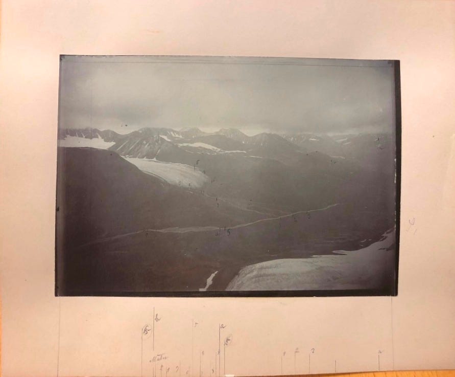
Snow-covered mountain shoulders emerged and disappeared again in the mist. Over Sarek’s central ridge, glimpses of the panorama materialised that I had seen in the map room before my journey.
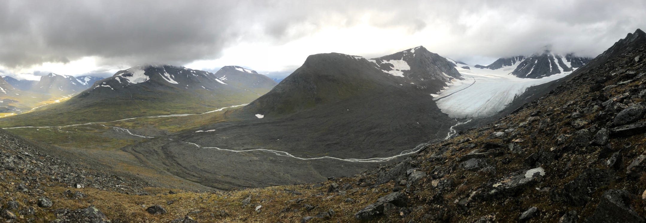
The peak of Sarektjåhkkå pierced Mikka Glacier, as if riveting the sheet of ice. From its brim, meltwater wound down the valley, as if unravelling the stub of ice. Further down, the coal-coloured face of Jållok swelled, driving a wedge into branching valleys.
Three glass plates form the panorama Axel Hamberg shot in 1907. Since then, two kilometres of ice have melted away.
Like a silver thread on black velvet, the glacier stream flows across a shadow Mikka left behind.
A century later, the tones of the glass negative have pressed into reality.
Waymarks
The past that has entered our vision cannot be unseen.
Many of the lines I had followed through Sarek would carry into later work. One evening in spring, a few years later, I received a mail.
The subject line read “Tyrone Martinsson”.
My resistance to click was physical.
Several summers ago, Tyrone had taken the time to reply to the lengthy email of a stranger – someone who was passing through Gothenburg on his way to Sarek.
I took the news of his passing on a walk.
The resonance of our conversations had stayed with me, on a path I had only just begun to follow.
Near the village where I grew up, I stood in vineyards that ebbed out from the foothills of the Black Forest. From atop, my view wandered across the River Rhine, to the Vosges Mountains on the other side.
Tyrone was one of the people who inspired the way I read landscapes. Meeting him was, as some translations of the Bible put it, a waymark (Jer 31:21).
Overlooking the panorama of my childhood, I sensed the contours of the imprint he had left – lines he had made me notice beneath our feet.
Further Reading and References
All translations and photographs are my own unless noted otherwise.
For geographical names in Sámi language I follow their rendering on the latest maps published by Lantmäteriet. The spelling used by this Swedish authority follows the local dialect in which the sites are located; see their guidelines described on lantmateriet.se.
Per Holmlund and Tyrone Martinsson, Frusna ögonblick. Svensk polarfotografi 1861–1980, Stockholm 2016.
On Hamberg see Sarek, Arktis och akademisk vardag. En bok om geografen Axel Hamberg, ed. Lars Andersson, Uppsala 2012.
Rich resources on Hamberg are provided by the Alvin Portal and by Lars Andersson’s Axel Hamberg Homepage (in Swedish).
As one publication from many, see Per Holmlund, “Mikkaglaciären. Bed topography and response to 20th century climate change”, Geografiska Annaler 68 (1986), 291–302.
Per’s son Erik had assembled some hundred photographs taken in 2018 from a helicopter over the Mikka Valley to a 3D-animation. Clickable hotspots introduce the systems of crevices, the qualities of snow, the accumulation zone that feeds the glacier, as well as areas where rock has started to tear trough the ice sheet. See Erik Schytt Mannerfeldt, 3D-Model “Mikkaglaciären 2018 in Sarek, Sweden” , online on SketchFab.com.
Lars Andersson provides an online documentation of the huts on the Axel Hamberg homepage (in Swedish).
For an overview on the early research and the methods applied see Axel Hamberg, Die Gletscher des Sarekgebirges und ihre Untersuchung. Eine kurze Übersicht, Stockholm 1910.
Tyrone Martinsson, “The Arctic Regions – Visual Stories from a Changing North”, PhotoResearcher 31 (2019), 242–257, p. 243.
W.G. Sebald, The Rings of Saturn, transl. by Michael Hulse, London 2002, p. 62.
See Julie Cruikshank, Do glaciers listen? Local knowledge, colonial encounters, and social imagination, Vancouver 2005.
See Axel Gavelin, Die Gletscher des Norra Storfjället und des Ammarfjället, Stockholm 1910, pp. 36–42.
On the Elysian dimension Rudbeck the Younger assigned to the willow tree see part I and part II of the article “Towards a History of Everything” (start here for the willow tree).
On Hammarskjöld’s Vägmärken and relationship to nature see the article “The Flowers” on this platform.

Published as Dag Hammarskjöld, “Kring fyra lägerplatser”, Svenska Turistföreningens årsskrift 1947, 331–47 (online at runeberg.org).
Axel Hamberg, Sarekfjällen. Vägledning för färder i högfjällen mellan Lule älvs källarmar, Stockholm 1922 (online at axelhamberg.se).