

The Northern Atlas – Conceived
How a 17th-century panorama placed Mount Atlas in the North.

Unlike Anything Else
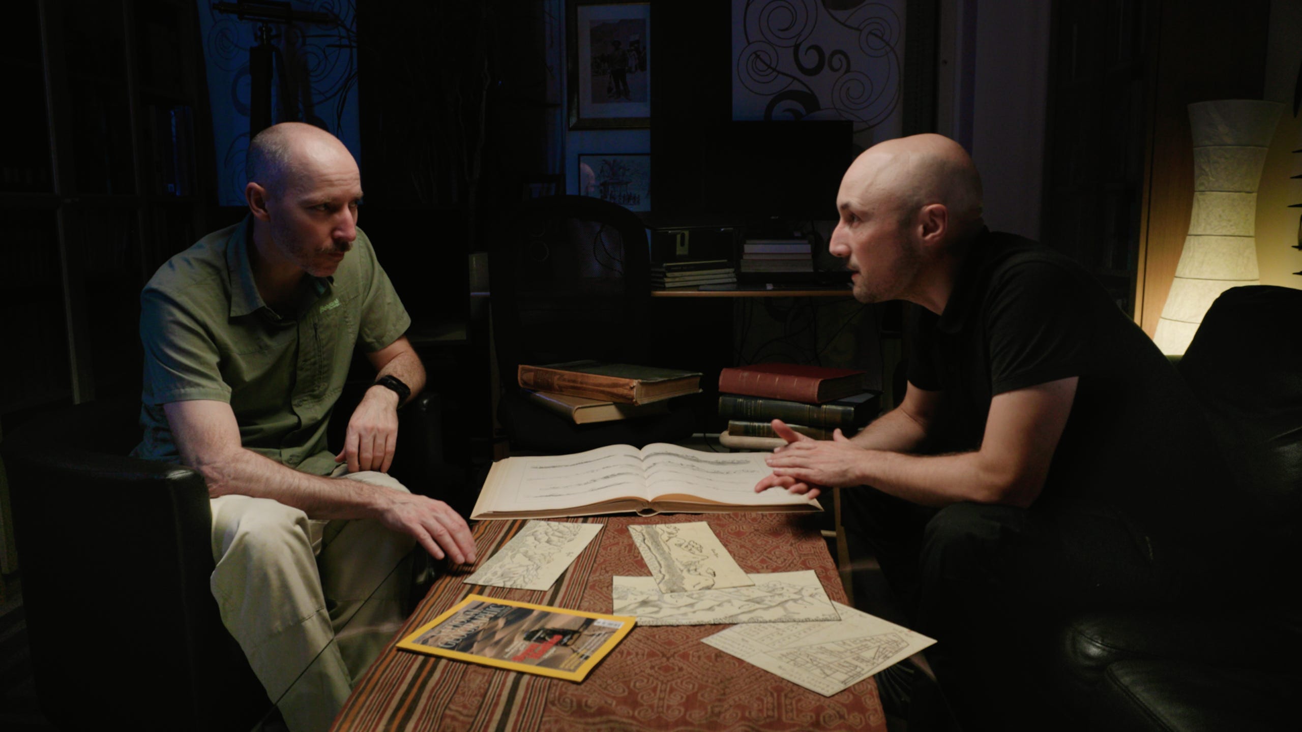
Lars leaned over the table, his finger moving slowly across the image.
I followed his gesture as he spoke of panoramas he had traced through the deserts of Central Asia and the Himalayas.
What I had brought to his desk was something different, closer to the mountains where he lived.
“To be honest,” Lars said, “I’ve never seen anything like this before.”
For a long time, we spoke about the 17th-century panoramas that had brought me to Åre – the first depicting the mountain chains of northern Sweden. The next day, we set out for the peaks of Jämtland, to find the point from which this view might open.
The opening minutes of Frozen Atlantis return to this encounter.
It marked a journey that had begun the year before, when I first followed one of these panoramas into the landscapes that it claimed.
Printing it from a digital copy of Olof Rudbeck’s Atlantica, I set out for the North.
Mythical Heights – Rudbeck Claims Mount Atlas
The volume of plates illustrating this 17th-century work a total of three views from the main ridge that separates Sweden from Norway.1 On many occasions, Rudbeck made use of these representations to link ancient myth to Swedish landscapes.
In the mountains and nature up north, in their shapes and names, he saw evidence that ancient geographers, naturalists, and mythographers had meant these peaks and their flora when they spoke in awe of the Hyperborean Mountains, the Mountains of Atlas, and the pines growing on them. In fact, Rudbeck went so far to boast that Sweden could boast no less than the highest mountains in Europe.
Among interpreters of ancient texts, such claims were far from uncontested.
“Erudite men such as Salmasius, Vossius and others,” Rudbeck complained in a letter to his protector Magnus Gabriel de la Gardie, “do not believe that our mountains are so high above sea level that they could be called the Hyperborean Mountains, of which the most ancient authors of the world have written so much.”2
One of the intellectuals in Rudbeck’s crosshair was Isaac Vossius. Since 1648, the Dutch bibliophile had served as court librarian to Queen Christina – one of the humanist heavyweights the Swedish monarch had attracted to her court in Stockholm.
Among his works, Vossius counted a commentary on Pomponius Mela. This Greek author ranked among the foremost writers on geography.
Mela, too, had touched on the mythical Hyperborean Mountains. However, as Vossius stated in his commentary, all attempts to locate the disputed range in the North must be considered fairy tales, as the local mountains merely rise to humble size:
The Norwegian mountains are considered to be the highest up north, but none of them rises to two stadia of altitude.
Isaac Vossius, Observations on Pomponius Mela 3
Judgements like this from armchair scholars such as Vossius, Rudbeck complained, had blurred the vision of the North. They had prevented learned men from acknowledging the role his country could deservedly claim: the one and only environment that had inspired our earliest myths and stories.
With his Atlantica, Rudbeck aimed to end this debate once and for all.
The 1675 Expedition
By the middle of the 1670s, Rudbeck had delved deeply into preparing the first volume of this work. Four years before its first volume appeared in 1679, he sent out an expedition up the Dalälven.
Up in the mountains where this river springs, the men procured material to correct the role Sweden had played in world history – a role that Rudbeck saw forgotten and distorted for millennia:
I am now sending out two students of mathematics at my own expense who shall travel from the Baltic Sea, where the Dalälven enters, and all the way upstream to measure the highest mountains, in order to see how high our mountains are ...
Olof Rudbeck, Letter to Chancellor De la Gardie (1674) 4
The Dalälven marks the border to Norrland, a name traditionally used for the northern part of Sweden. In the summer of 1675, Rudbeck’s men travelled upstream, towards lands the Crown had (re)gained with the 1645 peace treatise of Brömsebro.
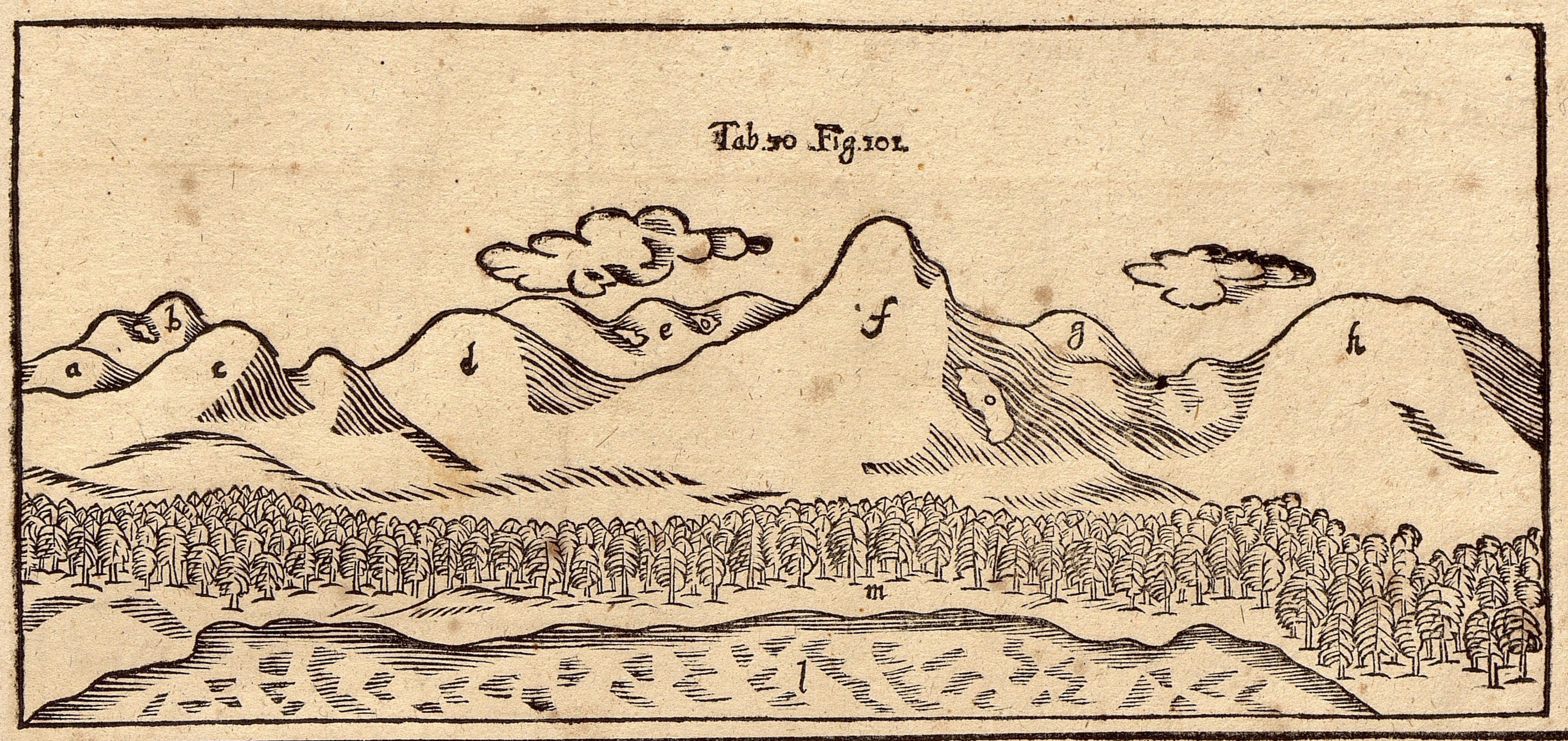
From the Swedish-Norwegian border mountains, they returned with a rich harvest. In Uppsala, Rudbeck drew on their maps, mountain measurements, and panoramas to rewrite the history of Sweden.
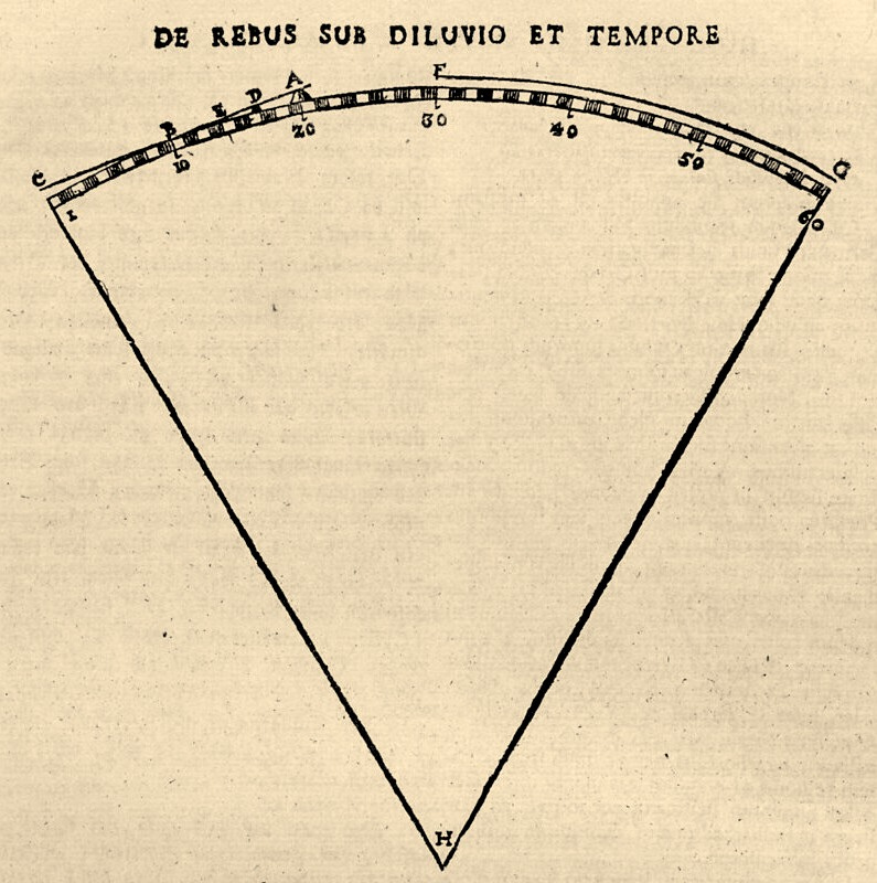
At his desk, Rudbeck brought together the data. He connected the relative height measurements his students had taken of peaks near Idre and further north in Jämtland with calculations of their ground level. For this, traced the levels of the waterfalls in adjacent rivers down to sea level.
On this basis, Rudbeck concluded that the top peaks of the main ridge must at least be ten times higher than the maximum altitude Vossius had claimed (2 stadia, approx. 360m).5 His calculations thus elevated Sweden’s peaks above those considered the highest in Europe at the time.
Yet the meaning of numerical claims was eclipsed by their historical implications.
As Sweden owned the highest mountain, Rudbeck argued, this put his country first when it came to tracing from where the earth was repopulated after the Biblical Flood. Where the mountains rose highest, he elaborated, land first emerged again in Europe. So it must have been here in the North, he concluded, that Noah’s son Japheth found first land as the waters began to recede.
Atlas Slabbed – The Myth According to Ovid
The implications of the expedition material extended far beyond the biblical narrative.
A signature claim of Rudbeck’s work was that the legendary island Atlantis identified as Scandinavia. In his Critias, the Greek philosopher Plato relates that the god of the sea had made his first-born son the first king of the island called Atlantis (Greek for ‘of Atlas’).6
As namesake of the island, Atlas came close to a patron of Rudbeck’s Atlantica itself. In the work, Rudbeck had a closer look at the myths about the god.
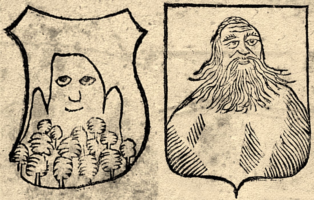
In his Metamorphoses, the Roman poet Ovid tells how the mountains of Atlas came into being.
When Perseus, returning from his victory over Medusa, sought shelter at the realm of Atlas, the giant refused the castaway entry. Warned by an oracle that a son of Jupiter would one day claim his garden, Atlas drove the hero away.
Perseus did not insist. Turning his eyes aside, he raised the head of Medusa instead with her petrifying glance:
His hair and beard were changed to trees,
his shoulders and arms to spreading ridges;
What had been his head was now the mountain’s top,
and his bones were changed to stones.
Then he grew to monstrous size in all his parts
– for so, O gods, ye had willed it –
and the whole heaven with all its stars rested upon his head.Ovid, Metamorphoses, 4.657-62 7
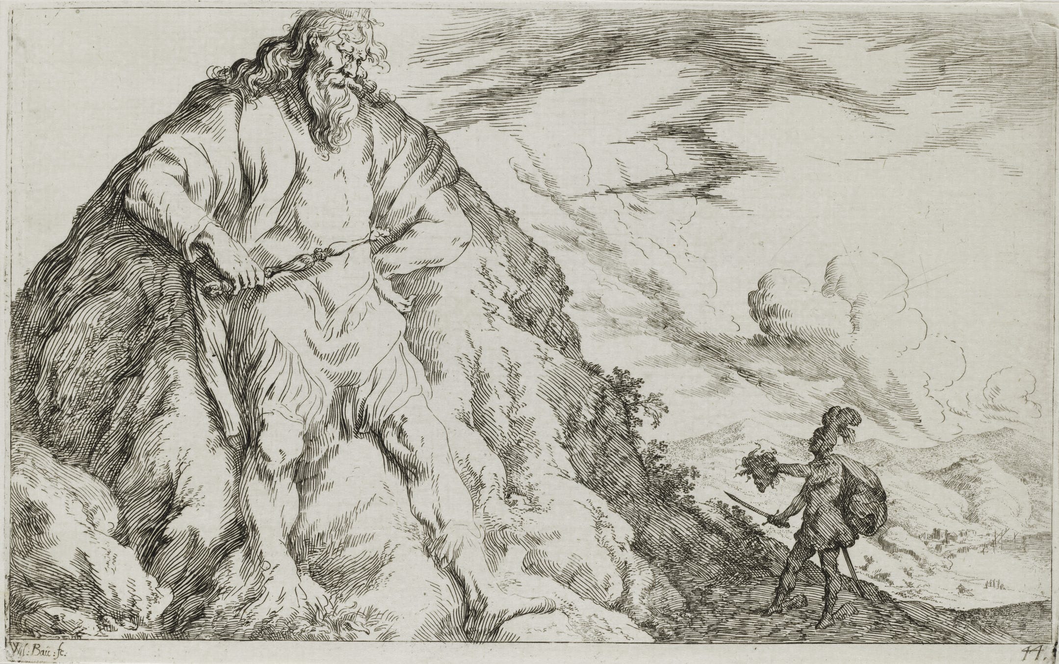
From that moment on, Ovid concludes, a sky-high mountain rose where the titan had stood – its forests the remnants of his beard, its mass the body of a petrified god.
For most readers, this mountain lay in Northern Africa.
For Rudbeck, it stood elsewhere. For him, Atlas was simply one among the many synonyms by which ancient writers had referred to the mountains dividing Sweden and Norway.8
When his expedition returned in 1675, their reports and drawings provided Rudbeck with new evidence. Up north, he argued, the treeless top of Mount Städjan – seen at the centre of his panorama (f) – perfectly corresponded to the bald head of Atlas of which Ovid had spoken. And so did the forest at his foot (m), in which the poet had, in Rudbeck’s interpretation, seen the transformed remnants of Atlas’s Beard.
An anthropomorphising view on the Swedish mountains lay behind the myth that Ovid still remembered, Rudbeck concluded. From his library at Uppsala, he presented further evidence to sustain this view. Manuscripts he consulted, Rudbeck relates, showed a wider image tradition connected to the theme of bearded-god-turned-forested-mountain.9
Taking Bearings with Vergil
Among the other authors on whom Rudbeck drew was Vergil.
In the Aeneid, the god Mercury, sent from Olympus, crosses the world in flight. As he approaches his destination, Vergil writes, he turns to Mount Atlas – a towering range whose pine-covered peak rises into the clouds and guides the migrating birds:
Soon in his flight he saw the steep flanks
and the summit of strong Atlas,
who props the heavens with his head;
Atlas, whose pine-covered crown is always wreathed
in dark clouds and lashed by the wind and rain:
Fallen snow covers his shoulders,
while rivers drop from the old man’s chin,
and his rough beard bristles with ice.VERGIL, Aeneid, 4.346–51 10

For Rudbeck, everything in this passage pointed north.
The rivers described by Vergil, he argued, corresponded to the great waterways descending from the Scandinavian mountains.11 The snow, visible even in summer, his expedition had confirmed (and added to the panoramas, see (o)).
What remained was the forest.
Seeing the Pines of Atlas
Vergil pointed to the trees on Atlas as its ‘pine-covered crown’, whereas Ovid poetically spoke of his beard. Other ancient authors offered clues as for the nature of the forest.
Pliny described Mount Atlas as crowned with unfamiliar trees similar to the cypress, its heights covered in snow even in warmer seasons.12
Among the conifers illustrated in his Atlantica, Rudbeck identified a match: the Swedish spruce. Its narrow form, he argued, was perfectly adapted to heavy snowfall – the only tree that fulfilled the conditions described in the ancient texts.

In Rudbeck’s panorama, natural history and classical mythology converged into a single view.
What had seemed scattered across texts and landscapes appeared as part of the same order. Mount Atlas, Pliny’s forests, Ovid’s giant and his beard – they all found their place in the reality of the North.
It only required the right eye to see.
Follow to the mountains around Idre in the second half of this article

Further reading and references
All translations and photographs are my own unless stated otherwise.
Please note the general bibliography available here.
See note no. 4.
Isaac Vossius, Observationes ad Pomponium Melam de situ orbis, The Hague 1658, pp. 106–7: “Norwagici montes omnium qui sunt in septentrione altissimi esse creduntur, attamen illorum nullus est, qui ad duorum stadiorum perpendiculum assurgat.” (digitised by Bayerische Staatsbibliothek München). The original passage from Pomponius Mela is lib. 1, cap. 19.
See the full passage in the letter by Olof Rudbeck to Chancellor Magnus Gabriel de la Gardie (15 July 1674), printed in Bref af Olof Rudbeck d.ä. rörande Upsala universitet, ed. Claes Annerstedt, vol. 2: 1670-1679, Uppsala 1889, no. 30, p. 97 (online at KB):
“Eliest wadh mit wärk anlanger så går dett nu Festina lente, ty iagh har ännu ej bekommmit de medel H. K. Maj. migh nådigast där till gaff. Och än då är iagh så pickhågat til at altidh nogot göra til min fäderneslands och public tienst att iagh nu sender 2 Mathes. studiosos på min omkostnat som skola resa ifrån Östersiön där Dalelffvan inlöper och henne alt up til högsta fiellarna affmeta att se huru höga wåra fiellar äro, emedan de lärda såsom Salmasius, Vossius och andra ei tro att wåra fiellar så höga äro mot haffvet att de kunna kallas Hyperboreorum Montes som de äldraälste i wärlden hafva så mycket skrifit om.”
The journey was scheduled for 1674, however left only the subsequent year.
Rudbeck’s addition results in 9135 cubits, ca. 26 stadia.
Cf. Plato, Critias, 114a.
After Ovid, Metamorphoses, tr. Frank Justus Miller, Cambridge (Mass.) 1921, 4.657–662: “nam barba comaeque / in silvas abeunt, iuga sunt umerique manusque, / quod caput ante fuit, summo est in monte cacumen, / ossa lapis fiunt; tum partes altus in omnes / crevit in inmensum (sic, di, statuistis) et omne / cum tot sideribus caelum requievit in illo.” (online at wikisource.org).
See e.g. Rudbeck, Atlantica, vol. I, pp. 340–46, 352–57, 566; vol. II, pp. 77–85.
I have not been able to identify the manuscript source of the images printed in the Atlantica.
After Vergil, Aeneid, 346–51: “iamque volans apicem et latera ardua cernit / Atlantis duri caelum qui vertice fulcit, / Atlantis, cinctum adsidue cui nubibus atris / piniferum caput et vento pulsatur et imbri, / nix umeros infusa tegit, tum flumina mento / praecipitant senis, et glacie riget horrida barba.”
See Pliny, Natural History, V.1.